
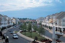
The attached map from The Huntersville Herald was really cool. I like how it lays out the area and color codes the future plans for the area around Birkdale. The only question that I have about this map that I haven't seen written about anywhere else is what the 'future development' is that is in the top left corner of the map. That would be the area along Catawba Ave in front of Robbins Park. I was always under the impression that Robbins Park would cover all of the land from McDowell Creek to Catawba.
Here's an except from Jason Pauling who's email I included in a previous post:
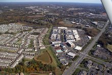
"Greenway master plans show proposed Upper McDowell eventually connecting to the Torrence Creek /Lower McDowell Creek greenway. Pauling said this will probably not happen for another five to 10 years, however. Plans to extend it in the north to Jetton Road extension may occur within a decade or so. It all depends on land acquisition. The county is currently working on plans to extend the Torrence Creek greenway from Cedarfield to Rosedale, and west from Cedarfield to Beatties Ford Road. That work is expected to begin next year and be completed sometime in 2008."


No comments:
Post a Comment